
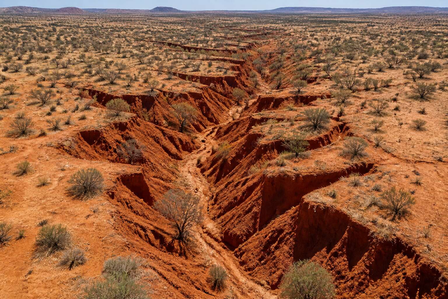
Causes of Soil Erosion in the Northern Cape Region
Climatic Factors: Drought and Heavy Rainfall Patterns
No landscape in South Africa is more exposed to the raw whims of weather than the Northern Cape. Here, the soil is perpetually on the edge, waiting for the next climatic shift to set it in motion. Two opposing forces drive soil erosion in northern cape: the dessicating drought and the sudden, violent rain.
Consider how each acts upon the fragile earth. The impacts differ markedly.
- Drought withers the grass and binds the soil into dust, leaving it vulnerable to the wind.
- Heavy rainfall hammers the bare ground, its droplets breaking the crust and washing soil into streams.
The crux is the cycle itself. A drought primes the land for disaster, and when the rains finally arrive, they do so with a force the cracked earth cannot absorb. Runoff gathers pace, carving gullies and stripping the topsoil that took decades to form. It is a quiet violence, repeated with every passing season, and it defines the persistent challenge of soil erosion in northern cape.
Overgrazing and Unsustainable Land Management Practices
Overgrazing removes the protective cover from the veld. Hoof pressure compacts the ground into a dense mass that repels moisture, and the top layer loses its coherence. This lapse stands as the most destructive trigger of soil erosion in northern cape, leaving the earth stripped to a brittle surface.
Land management often deepens this decline. These destructive patterns become routine:
- Keeping the herd on one depleted field until the grass roots vanish;
- Plowing on unstable slopes without proper contour lines;
- Burning the stubble that should hold the remains together.
Each habit grinds the soil into a powder that the open air claims without pause. We leave these farms poorer in structure every season, a quiet ruin built entirely from our own repetitive decisions.
Mining and Agricultural Activities Accelerating Erosion
Mining operations carve directly into the earth. In the Northern Cape, open pits and tailings facilities leave entire surfaces without cohesion. Windstorms lift fine particles from waste dumps and deposit them kilometres away, while heavy rainfall carves gullies through unrehabilitated ground.
Agricultural production accelerates soil erosion in northern cape, though through less obvious channels. Mechanised crop rows on gentle gradients act as conduits for runoff. Sodic irrigation water destabilises clay particles, turning once stable soils into a mobile slurry.
- Haul roads from diamond and manganese mines divert natural drainage.
- Centre pivot circles leave exposed soil between the wheels, where erosion begins.
I’ve watched these wounds deepen across a single season. Both sectors feed a compounding crisis. Every tonne of lost topsoil from mining or farming further entrenches soil erosion in northern cape, making recovery more expensive and less likely.
Topography and Soil Types Susceptible to Erosion
The Northern Cape’s topography is unhelpful. Steep slopes and dissected plateaus direct rainwater into concentrated flows. The soil types are no better. Lithosols are thin and stony, clinging thinly to bedrock. Solonetzic soils contain sodium, which causes clay particles to swell and then detach. Arenosols are essentially sand, which moves with any wind. These materials move easily.
The unstable soils include:
- Lithosols, found on slopes, with shallow profiles that erode fast.
- Solonetzic soils, whose sodium content breaks down under rain.
- Arenosols, common in the Kalahari, which shift at every gust.
This combination of steep ground and weak soil means soil erosion in northern cape is a predictable outcome of normal weather.
Environmental and Economic Impacts of Soil Erosion
Loss of Agricultural Productivity and Crop Yields
Each centimetre of topsoil lost can take decades to regenerate! In the Northern Cape, the financial toll mounts as fields yield less every season. I have seen fragile soils, once capable of supporting staple crops, now struggle to hold moisture and nutrients. This directly reduces harvests and forces farmers to allocate more capital to fertilisers and irrigation.
Lower crop volumes affect local economies. Consumers pay higher prices, and rural communities receive reduced income. Transport and processing sectors also see thinner profit margins as supply chains shorten.
The economic consequences extend beyond the farm. Sediment flows into waterways, impairing water quality and aquatic life. The land loses its capacity to buffer weather extremes, deepening future vulnerability.
Soil erosion in northern cape is reshaping agricultural viability today.
Effects on Water Quality and Availability
A single thunderstorm over the Karoo flats can send tons of sediment into catchment areas. This soil erosion in northern cape degrades farmland and compromises the region’s water supply. Suspended particles cloud the water, while attached chemicals poison aquatic ecosystems. Water availability becomes precarious, especially in dry months.
Reservoirs lose capacity as silt accumulates. Water treatment plants must work harder, and the cost passes to consumers. I have seen storage dams reduced to shallow pools, their yields now unreliable! Groundwater recharge diminishes because eroded surfaces repel rainfall.
- Rising turbidity escalates treatment expenses
- Sediment reduces reservoir storage volumes
- Chemicals borne by eroded soil contaminate drinking sources
The economic weight falls on municipalities, industry, and agriculture alike. This erosion undercuts water availability today and for seasons to come.
Damage to Infrastructure and Private Property
The same forces that strip topsoil also undermine concrete, asphalt, and steel. Across farms and towns, soil erosion in northern cape is a slow demolition of infrastructure as much as a loss of farmland.
Roads buckle when gullies carve beneath their foundations. Municipal crews fill one washout only to watch another appear after the next storm. Private landowners shoulder repairs for collapsed fences, exposed pipelines, and destabilized building foundations. The costs are not abstract. They arrive as invoices for engineering assessments, earthmoving equipment, and replacement materials.
- Reconstruction of eroded farm access roads
- Stabilisation of building sites on sloped terrain
- Replacement of water and sewage pipes exposed by dongas
I have walked properties where erosion has turned a backyard into a ravine. This is the real cost of soil erosion in northern cape. The value of the land falls, and insurance premiums rise. For many families, the expense forces impossible choices between repair and survival.
Impact on Biodiversity and Fragile Ecosystems
The arid expanse of the Northern Cape might seem resilient, yet its ecological fabric is astonishingly delicate. When soil erosion in northern cape strips away the thin, nutrient poor crust, it does not merely expose earth. It erases entire micro habitats that have taken decades to establish. The loss of this biological matrix is often invisible until the silence of the landscape becomes deafening.
The impact on biodiversity is profound and cascading. As topsoil vanishes into gullies and river systems, the flora that anchors the dunes and stabilises the pans disappears. This, in turn, dismantles the food chain for endemic insects, reptiles, and ground nesting birds. The Kalahari’s unique succulents and grasses, which are specially adapted to the harsh sun, cannot recolonise the scarred land without the original soil structure.
– Loss of seed banks buried beneath the surface
– Disruption of the natural water filtration cycle
– Destruction of burrow systems for small mammals and arachnids
These fragile ecosystems are not just scenic; they are functional engines of the regional economy. Eco tourism relies on the pristine nature of these landscapes. When erosion degrades the land, the appeal fades, and the revenue that flows into conservation efforts dries up. The cost is borne by the entire province, as the wild spaces that define this part of South Africa are permanently altered. This is the silent, creeping price of soil erosion in northern cape, a debt that grows with every passing storm.
Socio-Economic Consequences for Local Communities
In the arid stretch of the Northern Cape, the local grain cooperative has long been a barometer of prosperity. This is the hard arithmetic of soil erosion in northern cape. When topsoil leaves its place of origin, it takes the community’s spending power with it. Orders to local feed merchants wither, and sellers rush to offload thinner livestock, damaging the district’s reputation for quality. The cascade begins with:
- Municipal rates go uncollected from faltering farms.
- A generation of labourers migrates to coastal cities, splintering families.
- Small grocery stores shrink their inventory, raising the cost of mealie meal and bread for those who stay.
What remains is a hollowed-out local economy, where residents pay a premium for basics, a quiet tax exacted by the ground under their feet.
Affected Areas and Erosion Hotspots in the Northern Cape
The Kalahari Desert Margins and Dune Instability
The Kalahari’s ancient dunes are on the move again, and the trigger is visible from space. Along the desert margins, soil erosion in northern cape appears where the thin grass cover fails to bind the sand. What were once stable ridges are now bare crests, shaped by wind into fresh barchans.
The hotspots cluster in predictable locations:
- the Kgalagadi border country
- the sandveld near Van Zylsrus
- the rangelands around Askham
I have walked these margins and seen the difference a single season makes! Each site shares a signature, dune fronts advancing onto hardpan and burying old fence lines. The instability spreads from crest to crest, redrawing the boundary between usable land and bare sand.
The Orange River Catchment and Riparian Erosion
The Orange River carries the province’s water supply, yet its banks are collapsing. Riparian erosion along the catchment transforms productive floodplains into bare, scoured channels. I have driven the gravel roads near Prieska and seen where the river has undercut its own terraces, collapsing metres of soil into the current each rainy season. The affected areas share a pattern; degraded banks, displaced sediment, and losses that accumulate quietly.
Soil erosion in northern cape accelerates where irrigation relies on the river’s flow. The hotspots line the reach from Douglas to the Augrabies Falls. Key clusters include:
- the bank slumps near Griekwastad
- the incised channels below the Boegoeberg Dam
- the collapsing terraces at Kanoneiland
Each locale shows the same pattern, with water eroding the riparian zone faster than vegetation can bind it. The catchment’s erosion now delivers silt to the river, burying the gravel beds and altering the flow regime.
The Karoo and Bushmanland Regions Under Threat
In the Karoo and Bushmanland, soil erosion in northern cape follows the old sheep routes and dry riverbeds. The hotspots cluster around the Sak and Sout Rivers, where hoof traffic and flash floods have stripped the topsoil to the dorbank. Near Williston and Carnarvon, the landscape shows it plainly: gullies that started as wheel tracks now stand two metres deep. I have watched the sides crumble without a raindrop in sight.
The affected areas share one trait. The ground is thin, and once it goes, it does not come back. Bushmanland’s pans catch the wind after the rain, and the loose sand moves across the corrugated surface.
- Hotspots along the R355 and R27 corridors
- Incised channels near Fraserburg and Sutherland
- Scoured alluvial flats along the Sak River
Mitigation Strategies and Prevention Techniques
Revegetation and Afforestation Initiatives to Stabilise Soil
Somewhere in the arid expanse, a quiet battle is being waged against the relentless loss of ground. The solution does not lie in grand concrete barriers, but in the patient return of indigenous life. We are witnessing a shift towards revegetation and afforestation initiatives designed to stabilise the soil before it vanishes entirely.
Windbreaks of hardy, native species are being established along vulnerable boundaries to break the force of the dry wind. In other areas, the focus is on grass seeding after the first rains to lock down the topsoil with intricate root systems. These methods are not a quick fix; they are a long-term commitment to the land.
A practical approach in the region often involves:
- Establishing nurseries for locally sourced, drought-resistant plants
- Using erosion blankets and mulching to protect seeded areas
- Installing gabions or brushwood barriers to slow water runoff
Such interventions are gaining traction as farmers and landholders realise that prevention is far more economical than reclaiming lost earth. The ecological benefits extend beyond the visible landscape. As root networks expand, they create a sponge effect, allowing moisture to penetrate deeper rather than carving destructive gullies across the surface. This biological armour is the most potent defence against the dual threats of drought and flash floods.
The approach requires a change in perspective, viewing the land not as a mere resource, but as a living entity that needs constant care. Soil erosion in northern cape is a formidable opponent, but the region is starting to fight back with every seed planted and every root established. The hum of life is slowly returning to the barren spaces, one leaf at a time.
Water Management and Erosion Control Structures
Water determines the pace of soil erosion in northern cape. When heavy rains arrive, the landscape itself must slow the runoff before it gains momentum. Contour banks and earth bunds redirect flow across the slope, giving moisture time to infiltrate rather than carving channels through the topsoil. These structures are simple, but they depend on precise positioning and ongoing upkeep.
In steeper terrain, diversion channels and stone packing protect vulnerable slopes. Gullies respond well to masonry check dams, which lower water velocity and capture sediment before it leaves the property. Regulated outlets and reinforced grass waterways transfer surplus water without eroding the ground beneath them.
- Terracing on gentle slopes reduces the length of uninterrupted runoff
- Floodplain reconnection allows floodwaters to spread naturally
- Gabion baskets stabilise stream banks and slow bed movement
Every structure works with the local topography, turning intense storms into a manageable event. The result is measurable: less soil lost, more water retained, and a landscape that recovers faster after each rainfall.
Policy Interventions and Community-Based Approaches
A grazing plan approved by neighbours carries more weight than a fine from a distant office. That is the premise behind the Northern Cape’s emerging policy shift. Municipal bylaws and provincial land care programmes now require such plans before farmers access drought relief. The condition moves accountability from paperwork to the people who read the veld every morning.
Community based approaches fill the gaps where enforcement stalls. Neighbourhood committees map erosion hotspots and coordinate labour days to maintain existing structures. Local schools adopt nearby gullies as practical outdoor classrooms. Land reform beneficiaries receive mentorship in conservation agriculture alongside title deeds.
Policy levers matter:
- Conditional drought relief tied to grazing plans
- Municipal bylaws restricting land clearing
- Provincial funding for erosion hotspot mapping
Traditional councils integrate soil protection into seasonal calendars. Soil erosion in northern cape is a governance problem as much as a geological one, and the response must reflect that.
Monitoring and Early Warning Systems for Erosion Risk
The cost of late action is steep, measured in lost topsoil and ruinous repair bills for damaged farm infrastructure. Shifting from reactive fixes to proactive measures requires a clear-eyed view of the land’s condition, not a guess. This means moving beyond visual inspections after a storm and building a persistent picture of what is happening on the ground.
Monitoring and early warning systems are becoming the front line of defence against soil erosion in northern cape. Land managers are deploying a combination of ground sensors and satellite imagery to track soil moisture, vegetation cover, and the movement of sediment. This data provides a factual basis for decisions, such as when to move livestock or where to prioritise maintenance of erosion control structures. The information is only useful if it is shared. Local agricultural unions are establishing shared digital platforms where farmers can log their own observations, flagging a developing donga or a washout on a jeep track before it expands.
Specific techniques guide this work:
– A network of rain gauges and stream flow meters to trigger early alerts for high-risk rainfall events.
– Annual drone surveys to map gully head migration and measure changes in dune crests.
– Community-driven training on how to interpret satellite data and translate it into field action.
When a warning comes, the response is immediate and deliberate. Farmers adjust stocking rates, clear blocked waterways, and re-reinforce vulnerable slopes. The success of these systems relies on consistency and a shared understanding of the thresholds for action. By knowing precisely where the land is failing, stakeholders can apply the right tools at the right time, directly addressing the drivers of soil erosion in northern cape.
Economic Incentives for Long-Term Land Stewardship
In the Northern Cape, money, not rainfall, determines how fast a donga advances. I have seen landowners who acknowledge the erosion but then stall when the quote for gabions or grass seed arrives. The obstacle is not ignorance; it is the cost of today against a return that may only appear in later seasons.
Economic incentives are now built to close that gap. Agricultural lenders, input suppliers and municipal extension programmes are tying support to verifiable conservation work.
- Tax rebates for permanent grass cover along slope crests and banks
- Loans tied to a measured reduction in sediment yield from an operating unit
- Shared grants for drainage banks restored on communal grazing land
This structure puts conservation inside the regular financial picture. When protecting the soil operates as a normal cost of production, soil erosion in the northern cape is no longer a distant catastrophe. It is simply another line, measured, budgeted and handled like any input on the farm.


0 Comments