

Comprehensive travel route outline
Planning the journey and routes
Three landscapes, one journey. The route from the northern cape to gauteng blends desert dawns with city glow. “The road ahead teaches more than the map shows!” a veteran driver says—and this journey proves it again and again.
Planning the journey begins with a solid travel route outline. I map the corridor that links this region with Gauteng, selecting clear waypoints to balance scenery with momentum:
- Identify the primary corridor (N12/N14) connecting Northern Cape towns to Gauteng centers, with Kimberley and Klerksdorp as milestones.
- Pinpoint rest points, fuel stops, and easy scenery breaks to stay comfortable.
- Estimate travel times and seasonal factors to avoid surprises.
Along the way, the landscape shifts—from arid plains to a modern skyline—reminding us that this journey spans more than distance; it’s a study in pace and possibility.
Road infrastructure and safety
From the edge of the arid plains to the glittering horizons of Gauteng, the road whispers tales of distance and destiny. “The road ahead teaches more than the map shows!” a veteran driver once murmured, and I have learned to listen. The northern cape to gauteng corridor unfolds like a mythic thread, weaving weathered landscapes with steel-blue skylines.
Comprehensive travel route outline hinges on robust road infrastructure and thoughtful safety design. The backbone is the N12 and N14, an arterial weave linking Kimberley to Klerksdorp and onward toward Gauteng’s pulsating heart. Concrete and asphalt narrate maintenance, drainage, and the quiet rhythm of reliable signage that keeps time with the horizon.
- Road alignment, material quality, and drainage across the corridor
- Maintenance cycles, service networks, and resilient fuel stops
- Signage conventions, visibility cues, and safety standards guiding pace
In this landscape of scales, the route becomes a living atlas—ambitious, calm, and unforgettably alive.
Experience highlights and stops along the route
From arid flats to Gauteng’s electric skyline, the northern cape to gauteng corridor writes its own itinerary in sunlit asphalt. A veteran driver once whispered, “The road ahead teaches more than the map shows.” This thread of N12 and N14 unfolds as a living map, calm yet alive.
Experience highlights and stops along the route include:
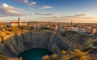
- Kimberley — Big Hole and heritage trails
- Potchefstroom — academic vibe, botanical gardens
- Klerksdorp — museums, family quarters
- Krugersdorp — gateway to Gauteng’s highveld and arts
The journey is a pulse—pace, place, and possibility—an atlas that invites walking, not merely charting the corridor.
Content optimization and SEO considerations
From the arid fringe to the electric pulse of Gauteng, the northern cape to gauteng corridor is not mere mileage; it is a storytelling seam where weathered road shoulders become backstage to the South African crossing. A striking fact anchors the journey: millions travel these arteries each year, seeking commerce, memory, and a horizon lit by sunrise. The outline I draft for this article treats the route as a living map—curated, precise, and intensely human—inviting readers to feel the distance rather than simply measure it.
To render this travel corridor in search results and on the page, structure, cadence, and relevance must join hands.
- The corridor as a semantic tapestry, weaving themes across sections
- Metadata and headings that whisper intent and invite traversal
- Interlocking references to related chapters—planning, routes, experiences
- Imagery with descriptive alt text that echoes pace and mood
The tone stays professional yet intimate, a balance of data and texture that respects the reader’s time and curiosity.


0 Comments